NTT Docomo, au and SoftBank cover Okinawa, and your eSIM will use one of them. Japanese networks are excellent and the main island is well served. Our Tokyo guide covers the Japanese questions you would otherwise ask here - underground signal, Suica on your phone, and how cashless the country actually is. What Tokyo cannot tell you is that Okinawa is not really the same country in most of the ways that matter to a visitor, and that it is closer to Taipei than it is to Tokyo.
Okinawa was the Ryukyu Kingdom, an independent maritime state trading with China, Japan, Korea and Southeast Asia, until Japan annexed it in 1879.
The distance is the first surprise. Naha is about 1,550 km from Tokyo and roughly 630 km from Taipei. Flying here from mainland Japan takes as long as flying to Seoul.
The language is genuinely separate. Ryukyuan languages are related to Japanese but not mutually intelligible, and UNESCO classifies several as endangered. Older people still speak them; everyone speaks Japanese.
The food is different. Goya champuru, rafute, taco rice, sea grapes, and awamori rather than sake - Okinawan distilled spirit, aged in clay.
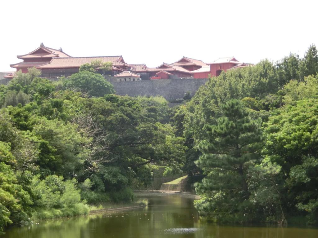
The architecture is different too: red tile roofs weighted against typhoons, shisa lion-dogs on every gate, and family tombs shaped like turtle shells.
Karate originated here, in the Ryukyu Kingdom, and travelled to mainland Japan in the twentieth century.
Shuri Castle, the kingdom's seat, burned down in 2019. Reconstruction has been underway since, with the main hall due around the middle of this decade - check the current status before planning around it, because the site is open but partially a building project.
Worth understanding, because you cannot spend a week here without noticing.
Okinawa is 0.6% of Japan's land area and hosts over 70% of the US military facilities in Japan by exclusive-use area.
Kadena Air Base is one of the largest US installations in the Pacific, and Futenma sits in the middle of a dense residential area, which is why its relocation has been contested for decades.
You will see it constantly - fenced perimeters along main roads, distinctive housing areas, American cars, and aircraft noise that is genuinely loud near the bases.
It is a live political issue, not history. Referendums, protests and land disputes are ongoing, and Okinawan opinion is not the same as Tokyo's.
Practically, for a visitor: some roads run for kilometres alongside fence lines, the base areas are not accessible, and the American presence gives central Okinawa a hybrid character - taco rice exists for a reason.
Be thoughtful about it. Photographing perimeters is unwise, and the subject is worth discussing with locals only if they raise it.
Okinawa is the most typhoon-exposed part of Japan, sitting directly in the western Pacific track.
The season runs roughly May to October, peaking in August and September.
A direct hit closes everything. Flights and ferries stop, shops board up, buses cease, and hotels ask guests to stay inside. This is routine rather than exceptional and the island handles it well.
It is the ferries that strand people. Crossings to the Kerama islands and the outer chains are cancelled first and resume last, so never plan an island day trip immediately before a flight home.
Japan broadcasts emergency alerts by cell, reaching every handset on a Japanese network including roaming ones. They are loud and they override silent mode - leave them enabled.
Travel insurance matters more here in that window, and building a spare day into any trip in September is simply sensible.
Winter is lovely - mild, dry and quiet - though the sea is too cool for comfortable swimming for many people.
Public transport is limited. Naha has the Yui Rail monorail, and it is useful within the city and to the airport, and that is essentially the whole rail network.
Buses exist but are slow and infrequent outside the main corridors.
The main island is about 100 km long, and the good beaches, the aquarium and the northern forest are all a drive away.
Hire a car. It is what almost every visitor does, roads are excellent, signage is bilingual, and driving is on the left as in the rest of Japan.
An International Driving Permit is required for most nationalities, obtained before you travel - it cannot be arranged on arrival.
Traffic through the central corridor around the bases is genuinely heavy at peak, and the expressway is worth the toll.
Naha and the developed west coast are well covered, monorail included.
The Yanbaru forest in the far north, a UNESCO World Heritage site of subtropical woodland, thins on the trails - and it is home to species found nowhere else.
The Kerama Islands, half an hour by fast ferry, have coverage in the villages and patchy service on the beaches.
Miyako and Ishigaki, the far southern island groups, are separate flights away and are well served in their towns.
Underwater, obviously - and Okinawa is a serious diving destination, so plan surface arrangements accordingly.
On the ferries, coverage comes and goes across the channels.
- A car hire and navigation app. Japanese in-car satnav often works by phone number rather than address, which surprises visitors - your own maps app is easier.
- A translation app with camera input, for menus outside Naha.
- The Yui Rail app or any transit app for the monorail.
- A typhoon and weather app in season - the Japan Meteorological Agency's is authoritative.
- Suica or a transport IC card on your phone, which our Tokyo guide explains, and which works here too.
Naha (OKA) is the gateway, with the monorail running from the terminal into the city in about fifteen minutes.
Flights from Tokyo take about two and a half hours, from Osaka slightly less, and there are direct services from Taipei, Seoul and Hong Kong.
Car hire desks are at the airport and shuttle you to the depot - book ahead in summer, when the island genuinely runs out of cars.
Ferries to the outer islands leave from Naha's Tomari port for the Keramas, and Miyako and Ishigaki are reached by air.
Moderate. You will be driving and navigating for much of the trip, translation gets constant use outside Naha, and hotel wifi is reliable. Nothing here demands a large plan, but offline maps for the northern forest are worth having.
Beach and summer clothing for most of the year - this is subtropical and it does not get properly cold.
A light layer for winter, when 17C with wind off the sea feels cooler than the number.
Reef shoes. Okinawan beaches are coral and the rock is sharp; there are also stonefish and, seasonally, box jellyfish - swim inside the netted areas where they are provided.
Rain gear from May to October.
Modest cover when away from the beach. Japan generally does not wear swimwear off the sand, and Okinawa is no exception.
Something respectable for a nice dinner, though Okinawa is markedly more casual than mainland Japan.
Kerama Blue - the water colour off the Kerama Islands, which has its own name and deserves it. Half an hour by fast ferry from Naha.
Cape Manzamo, the elephant-trunk rock formation on the west coast, at sunset.
Churaumi Aquarium's main tank, one of the largest in the world, with whale sharks and manta rays behind a single enormous acrylic panel.
Shuri Castle, with the caveat above about reconstruction.
Kokusai-dori in Naha, the main street, for the shisa shops and the market above it.
Yanbaru forest in the north, all tangled subtropical growth.
Cape Hedo, the northernmost point of the main island.
Taketomi Island, off Ishigaki, with its sand lanes, water buffalo carts and traditional red-tiled houses.
Okinawa hosts over 70% of the US military facilities in Japan on 0.6% of its land, which is the single statistic that explains most local politics.
Karate was invented here, developed in the Ryukyu Kingdom and only introduced to mainland Japan in the early twentieth century.
Okinawa is one of the original Blue Zones - regions identified for exceptional longevity - and the traditional diet and social structures are the usual explanations offered.
Shisa - the paired lion-dogs on rooftops and gateposts - always come as a pair with one mouth open and one closed, to admit good and keep it in.
Naha's Great Tug-of-War uses a rope so large it has held a Guinness record, and tens of thousands of people pull on it each October.
And awamori is distilled from long-grain Thai rice, not Japanese short-grain, which is a trace of the kingdom's old trading routes.
The Naha Great Tug-of-War, in October, with an enormous rice-straw rope and a crowd in the tens of thousands.
Eisa festivals, through the summer, where neighbourhood troupes drum and dance through the streets - the Okinawa Zento Eisa Festival at the end of summer is the largest.
The Shuri Castle Festival, in autumn, with Ryukyuan court processions.
Typhoon season, May to October, which is not an event but shapes the calendar more than any of them.
March to May and October to November are the best windows: warm, drier, and outside the peak of the typhoon season.
The love: Okinawa is the most surprising part of Japan, and visitors who arrive expecting a beach annexe of the mainland find a place with its own history, language, food and music. The water is genuinely Caribbean in colour, the diving and snorkelling are world-class, the Churaumi Aquarium deserves its reputation, and the pace is slower and warmer than anywhere else in the country. It is also excellent value compared with Tokyo.
The complaints are consistent. You need a car, and without one the island shrinks dramatically. Naha itself is unremarkable - a functional city rather than a destination. The base presence is visually and audibly intrusive through the centre of the island. Typhoons can take days out of a trip. The best water is on the outer islands, which means extra ferries or flights. And visitors hoping for temples-and-cherry-blossom Japan are in the wrong archipelago entirely.
Come in April or November, hire a car on arrival, take the fast ferry to the Keramas for a day, and try awamori rather than sake.
Broadly yes - the same operators, the same excellent coverage on the main island, and our Tokyo guide's answers on underground signal and transport IC cards apply. The differences here are geographic rather than technical: the northern forest and the outer islands are where coverage thins.
Almost certainly. Naha's monorail covers the city and the airport, and that is the extent of the rail network. The beaches, the aquarium and the north are all a drive away, and buses are slow. Note that an International Driving Permit is required for most nationalities and must be obtained before you travel.
A direct hit stops everything - flights, ferries, buses and shops - usually for a day or two, and the island is well practised at it. Ferries to the Kerama and outer islands cancel first and resume last, so never schedule an island trip immediately before your flight home. Leave Japan's emergency cell alerts enabled; they reach roaming phones.
In the villages and towns, yes. On the beaches and trails of the Keramas, patchily. Miyako and Ishigaki are separate island groups reached by air and are well covered in their towns. Download offline maps for the Yanbaru forest in the north, where it drops out.